


Author : Sr Yap Kian Ann,
registered valuer & property consultants
July 14, 2026
Town Planning and Valuation
In Malaysia, property developments are guided and controlled under several established laws, regulations, and planning controls in order to promote planned, organised, and sustainable development, while safeguarding the public interest and achieving a balance between commercial development and society’s well-being.
The applicable laws, regulations, and planning controls include the National Land Code, the Town and Country Planning Act 1976, local plans, building by-laws, and various related legislation. These govern zoning, land use categories, density or plot ratio, building height limits, setbacks, and other development requirements.
Malaysia’s planning control framework is well established, with each local authority having its own Local Plan (Rancangan Tempatan) or Draft Local Plan applicable to its jurisdiction, e.g. Kuala Lumpur Local Plan 2040 and Draft Johor Bahru Local Plan 2035.
Kuala Lumpur Local Plan 2040 (PTKL2040) was gazetted on 28 May 2025. It was prepared by Kuala Lumpur City Hall (DBKL) with input from professionals, government agencies, industry representatives, stakeholders, and local communities. PTKL2040 translates Kuala Lumpur’s long-term vision of “A City for All” into a comprehensive planning framework by strengthening urban planning in line with sustainability objectives. PTKL2040 establishes planning strategies and identifies development proposals to guide Kuala Lumpur’s growth up to 2040. It serves as the primary reference for DBKL in assessing development applications and administering development within the city. The document also provides an administrative framework and planning guidelines for DBKL in carrying out its responsibilities as the local planning authority while taking into account the achievements of the Kuala Lumpur City Plan 2020 (PBRKL 2020).
In valuing development land or properties with redevelopment potential, registered valuers will always conduct planning checks on the permissible land use zoning, population density or plot ratio and other planning related matters.
Land Use Zoning
It is the process of dividing a territory into different zones and specifying the types of development and activities that are permitted or restricted within each zone. It is a planning tool used by local authorities to ensure orderly, sustainable, and compatible development.
Land use zones include residential, commercial, industrial, mixed-use, institutional, open space and recreation, and agricultural.
All proposed developments are subject to planning permission from the local planning authority. Such approvals typically follow the zoning stipulated in the local plan.
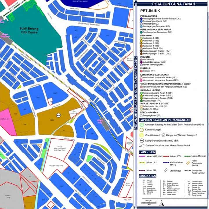
Below is a sample of the land use zoning extracted from PTKL2040.
Population Density
It is the number of people living within a given unit of land area, usually expressed as persons per acre (ppa).
Assuming that one dwelling unit accommodates four persons, a permissible population density of 100 ppa means that 25 dwelling units are permitted to be developed on every acre of land.
This method is gradually being replaced by the plot ratio as the primary measure of development intensity, particularly for non-residential developments.
Some of the reasons include:
More objective measurement – Plot ratio is based on the physical size of the building rather than estimated occupancy, which can vary significantly. For example, a 500 sq ft condominium unit and a 2,000 sq ft condominium unit are both counted as one unit under the population density approach, despite their substantially different floor areas.
Flexibility for mixed-use developments – Modern developments often comprise a combination of residential, commercial, office, hotel, and serviced apartment components. Plot ratio provides a single measure of development intensity applicable to all land uses.
Easier development control – Developers know exactly how much Gross Floor Area (GFA) they are permitted to construct.
Plot Ratio
Plot ratio, also known as the Floor Area Ratio (FAR), limits the maximum Gross Floor Area (GFA) that can be constructed on a parcel of land based on its land area.
The formula is:
Gross Floor Area = Land Area × Plot Ratio
For example, if the land area is 100,000 sq ft and the plot ratio is 1:5, the maximum permissible Gross Floor Area is 500,000 sq ft.
Usually, floor areas for amenities such as car parks are excluded from the computation. In a proposed development, land to be surrendered for roads, access, setbacks, and similar purposes may also be included in the permissible Gross Floor Area computation, subject to the applicable planning guidelines.
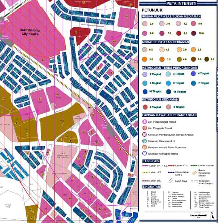
Below is a sample of the Plot Ratio/Density extracted from PTKL2040.
Why is the Town Planning Factor Important in Valuation?
Planning controls (zoning and density/plot ratio) are among the key factors in determining the market value of land.
The permissible land use and density allowed by the local planning authority directly affect what can be built on the land, as well as the amount of Gross Floor Area and the number of development units that can be constructed.
Purchasers of development land, who are primarily developers and investors, determine the price they are willing to pay after taking into consideration the projected Gross Development Value (GDV) based on the applicable planning parameters.
Generally, the better the land use classification and the higher the permissible development density, the higher the potential GDV, resulting in a higher residual land value (i.e. market value) and, consequently, a higher price that purchasers are willing to pay.
Based on an analysis conducted by Agility Valuers & Property Consultants Sdn. Bhd. using the Residual Method of Valuation, density/plot ratio has a direct positive correlation with land value. However, the increase in land value is generally lower, in percentage terms, than the corresponding increase in plot ratio.
The analysis found that:
When the plot ratio increases from 1:4 to 1:6 (a 50% increase), land value generally increases by 25%–30%.
When the plot ratio increases from 1:6 to 1:8 (a 33% increase), land value generally increases by 15%–18%.
Planning Factors Affecting Value
Planned roads, rail transit, utilities, schools, hospitals, and public amenities improve accessibility and convenience, making surrounding properties more valuable.
Zon Perancangan Transit (Transit Planning Zone – TPZ) refers to areas surrounding major public transport hubs (such as MRT, LRT, Monorail, or KTM stations). DBKL encourages Transit-Oriented Development (TOD) in these locations. Developments that meet TOD objectives may be granted higher plot ratios to promote higher-density, mixed-use, and pedestrian-friendly developments.
Zon Pengaruh Transit (Transit Influence Zone – TIZ) generally covers the broader area influenced by a transit station. While development intensity is usually higher than in ordinary areas, the incentives are typically less significant than those available within a TPZ, depending on the applicable planning policies and location.
When a future MRT station is included in a local plan, nearby residential and commercial properties often experience price appreciation because of improved accessibility, even before construction is completed.
Under urban renewal or redevelopment plans, areas identified for regeneration often experience value appreciation due to planning incentives and anticipated investment by developers. For example, under PTKL2040, plot ratio incentive provisions are available for areas identified as Lot Amalgamation Areas and Special Redevelopment Areas.
Environmental restrictions, such as flood-prone areas, environmentally sensitive zones, heritage conservation areas, or steep slopes, may impose development restrictions, thereby reducing market value.
Land identified for road widening or future land acquisition for public infrastructure projects may also become less attractive because of reduced developable area or planning uncertainty.
Registered Valuers
Registered valuers conduct planning checks because they establish the highest and best use of the property being valued.
Planning controls help valuers determine:
The legally permissible use of the land.
The maximum development potential.
Future redevelopment opportunities.
Risks arising from planning restrictions.
Comparable transactions involving land with similar planning characteristics.
Consequently, planning information is one of the most important factors in determining market value, particularly for development land.
How Could Planning Help Land Valuation Over the Long Term?
Over time, as the population increases, cities expand, and land within existing developed areas becomes scarce, outlying areas may be rezoned for development, making existing agricultural land suitable for urban development.
New infrastructure will be planned and constructed to support these developments, thereby enhancing the value of surrounding land.
When this occurs, plantation companies with substantial agricultural land banks may experience significant increases in asset values, sometimes by several folds.
Many of these companies subsequently venture into property development, benefiting from their relatively low land acquisition costs and consequently achieving higher development profit margins.
Is Plot Ratio / Development Density Correlative to the Selling Price of the Developed Units?
Theoretically, assuming a fixed land area for a development site, an increase in the permissible development density generally results in a lower average selling price per square foot of the completed units.
For example, on a 2-acre condominium development site, a scheme comprising a greater Gross Floor Area (GFA) and a larger number of residential units would typically require the units to be sold at a lower average price per square foot to achieve satisfactory market absorption, compared with a lower-density development on the same site.
In addition, a larger number of units within the same development generally results in greater congestion in the use of common areas and shared facilities, which may reduce the exclusivity of the development and place downward pressure on the achievable selling price per square foot.
Frequently Asked Questions
1.Why is town planning important in property valuation?
Town planning is one of the most important factors in determining the market value of land, particularly development land. Planning controls such as land use zoning, plot ratio, building height, setbacks, and development restrictions determine what can legally be developed on a site. These planning parameters directly influence the Gross Development Value (GDV), development potential, and ultimately the market value of the land. Consequently, registered valuers always conduct planning checks as part of the valuation process.
2.What is the difference between land use zoning and plot ratio?
Land use zoning determines the types of development that are permitted on a particular parcel of land, such as residential, commercial, industrial, mixed-use, or agricultural developments. Plot ratio, on the other hand, controls the intensity of development by specifying the maximum Gross Floor Area (GFA) that may be constructed relative to the land area. Both zoning and plot ratio work together to determine a property’s development potential and market value.
3.Does a higher plot ratio always increase land value?
Generally, yes. A higher permissible plot ratio allows a larger Gross Floor Area (GFA) to be developed, which can increase the Gross Development Value (GDV) and the residual land value. However, the increase in land value is usually proportionately lower than the increase in plot ratio because of higher construction costs, infrastructure requirements, financing costs, and market demand considerations. The actual impact also depends on location, market conditions, and planning restrictions.
4.How do Transit Planning Zones (TPZ) and Transit Influence Zones (TIZ) affect property values?
Properties located within a Transit Planning Zone (TPZ) or Transit Influence Zone (TIZ) generally benefit from improved accessibility to public transport, making them more attractive to developers, investors, businesses, and homebuyers. In many cases, developments within TPZs may also qualify for higher plot ratio incentives under local planning policies, increasing their development potential and market value. Even before a new MRT or LRT station is completed, nearby properties often experience value appreciation due to anticipated improvements in connectivity.
5.Why do registered valuers conduct planning checks before valuing development land?
Planning checks enable registered valuers to determine the highest and best use of a property. They verify the permissible land use, plot ratio or development density, building height limits, redevelopment opportunities, planning restrictions, and other planning parameters that affect development potential. Since these factors directly influence the market value of development land, planning information is an essential component of a professional property valuation.
Please feel free to contact Agility Valuers & Property Consultants Sdn. Bhd. should you require any further clarification or assistance regarding valuation matters. View our valuation services (link to https://www.agilitymy.com/our-services/advisory-en/valuation-and-advisory-services/)
———————————————————————————————————————————————————————
This blog / insight is based on Agility Valuers & Property Consultants / Agility Research (AVPC)’s current understanding and insights about the related topic in the current property / real estate market context. Agility Valuers & Property Consultants / Agility Research (AVPC) makes no guarantees, representation or warranties of any kind, expressed or implied, regarding the information including but not limited to, warranties of content, accuracy and reliability. Interested parties should undertake their own inquiries as to the accuracy of the information. Agility Valuers & Property Consultants Sdn. Bhd. / Agility Research (AVPC) excludes unequivocally all inferred or implied terms, conditions and warranties arising out of this document and excludes all liability for loss or damages arising therefrom.
Neither the whole nor any part of our blog or insights may be included in any published document, circular, prospectus or statement, nor published in any way without the prior written approval of Agility Valuers & Property Consultants Sdn. Bhd. / Agility Research (AVPC). We shall not be obligated to update this blog / insight in response to changes in market conditions or the regulatory environment subsequently.
For more information, please contact:
Sr Yap Kian Ann
Tel: 603-9544 2694 Email: yap@agilitymy.com
HP : 6012-378 5811 Website: www.agilitymy.com
All Rights Reserved
Copyright © 2026 Agility Research
